168
168
Oct 28, 2012
10/12
by
FOXNEWS
tv
eye 168
favorite 0
quote 0
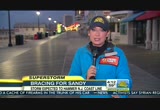
this will be the event they feared irene will be. it will be worse than the event they thought irene might be. it's an incredible storm. it is a hurricane right now, it is gaining energy from the warm water source it has here. but it is going to be tobegin a process of gaining energy from a cold air mass here across parts toward the eastern u.s., that combination will cause the storm to explode in its intensity. it is very strong. it is going to cause it to expand in its wind field. so we are talking about multi-facets to the storm. one is the rain. we are seeing the rain here across parts of the outer bank, with 5, 6 inches falling. but many areas will see 5 to 10 inches of rain. so there will be a lot of inland flooding. and the storm surge is the most deadly thing that comes from any kind of tropical storm. when have you a hurricane that comes into jersey, that puts the biggest and worst of the storm surge here to that upside-down l-shape. the water has nowhere to go and it causes potentially catastrophic flooding in new york city
this will be the event they feared irene will be. it will be worse than the event they thought irene might be. it's an incredible storm. it is a hurricane right now, it is gaining energy from the warm water source it has here. but it is going to be tobegin a process of gaining energy from a cold air mass here across parts toward the eastern u.s., that combination will cause the storm to explode in its intensity. it is very strong. it is going to cause it to expand in its wind field. so we are...
101
101
Oct 30, 2012
10/12
by
FBC
tv
eye 101
favorite 0
quote 0
initial estimates are 5 to 10, for irene they were 7, but irene was closer to 20, i think they will be as bad. but now, look at all stores that are closed, flights that have not gone out, hotels and businesses onshore and new york city that are down for 4 days, that is a loss of income. that is 20 billion that gets me to 40. gerri: wow, okay that makes sense. people underestimate the costs. i read new york city alone is an economy with $4 billion that pumps out $ 4 billion every day, times 5 is $20 billion, not just damage you repair. it is also the loss of productivity, workdays, loss payroll, it could be far more devastating than we've been talking babout, you also said, in short term painful but longer term we get a bunch of federal dollars that will pump energy into the economy. >> absolutely, if we have $20 billion in property damage we spend more than that rebuilding, we always do, on the shore property so valuable, they will build bigger homes and businesses. obsolete capital will be replaced by modern capital. we'd get multiplier effect, you spend a dollar on infrastructure, yo
initial estimates are 5 to 10, for irene they were 7, but irene was closer to 20, i think they will be as bad. but now, look at all stores that are closed, flights that have not gone out, hotels and businesses onshore and new york city that are down for 4 days, that is a loss of income. that is 20 billion that gets me to 40. gerri: wow, okay that makes sense. people underestimate the costs. i read new york city alone is an economy with $4 billion that pumps out $ 4 billion every day, times 5 is...
301
301
Oct 29, 2012
10/12
by
KPIX
tv
eye 301
favorite 0
quote 0
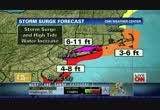
storm could be much worse than irene. here in maryland and farther up the coast including in new jersey. and that's where elaine quijano is, elaine? >> reporter: well, chip, we're in the town of bayhead, new jersey, which is especially vulnerable it sits just ten feet above sea level and like other coastal communities residents here have been ordered to evacuate. >> no, man, we have to go home, state of emergency. >> reporter: the race is on along the jersey shore to leave ahead of hurricane sandy. >> i got it, i got it. >> reporter: ted smith evacuated his 81-year-old mother althea from their house in bayhead. he's worried about the water pushing through their beach front home. >> the ocean will definitely come up this far. i mean if we look at the ocean right now, i mean it's coming up pretty high. >> reporter: throughout the region people from coastal towns are jamming highways and roads to escape the storm. forecasters predict as winds push water on shore, a storm surge could cause water levels to rise six to 11 feet,
storm could be much worse than irene. here in maryland and farther up the coast including in new jersey. and that's where elaine quijano is, elaine? >> reporter: well, chip, we're in the town of bayhead, new jersey, which is especially vulnerable it sits just ten feet above sea level and like other coastal communities residents here have been ordered to evacuate. >> no, man, we have to go home, state of emergency. >> reporter: the race is on along the jersey shore to leave...
332
332
Oct 29, 2012
10/12
by
WMAR
tv
eye 332
favorite 0
quote 1
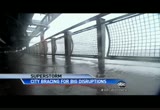
we have had more water from sandy than we did last year from irene. we are being told that p rotectively, they're going to shut off power downhill since so have everybody has gotten somewhere safe and sandy is coming the question i s, how will new york city handle it? >> the big apple has been shut down to its core. lower manhattan looks like a ghost town at wall street will be closed for consecutive days because of weather for the first time since the 18 hundreds. and place we have to look up to see were many people live, spiked scrapers are a concern and wind speeds on the ground or half of those of those on the top floors sometimes forcing buildings to s way. >> the further up you live, the re reason you should close your dreams and just stay away from windows. >> reporter: watched the bath water sloshing a brooklyn high- rise in gusts of barely 40 miles an h our, half of what is expected by sandy. at ground zero still under construction special precautions as teams worked at two get machinery tied down and fears heightened by 10-ton steel arm dang
we have had more water from sandy than we did last year from irene. we are being told that p rotectively, they're going to shut off power downhill since so have everybody has gotten somewhere safe and sandy is coming the question i s, how will new york city handle it? >> the big apple has been shut down to its core. lower manhattan looks like a ghost town at wall street will be closed for consecutive days because of weather for the first time since the 18 hundreds. and place we have to...
214
214
Oct 29, 2012
10/12
by
WUSA
tv
eye 214
favorite 0
quote 0
this is nothing like irene. it was a tropical storm, warm and it was just water. we may get the wind here. we may get some property damage and people here are bracing for some power outages. so that's about it for now. we're fortunate. for irene we actually had a tornado, haven't had anything like that in terms of property damage. lots of flooding that we've shown you. you showed the viewers footage from dewey beach, lots of that type flooding throughout the area because of all the water in coastal delaware, over 50,000 people ordered out, evacuations. it's a lot more than that now because a lot of people have left on their own. >> we'd like to see bruce a bit closer in. >> someone was giving him grief for being in a shelter earlier. we won't do that ever again. we also saw pictures out of atlantic city where the storm actually went ashore. you have entire sections of the boardwalk atlantic city washed out to the ocean, haven't seen anything like that. >> it's a powerful storm. we always tell crews in the field on days like this safety is their top priority. here'
this is nothing like irene. it was a tropical storm, warm and it was just water. we may get the wind here. we may get some property damage and people here are bracing for some power outages. so that's about it for now. we're fortunate. for irene we actually had a tornado, haven't had anything like that in terms of property damage. lots of flooding that we've shown you. you showed the viewers footage from dewey beach, lots of that type flooding throughout the area because of all the water in...
220
220
Oct 29, 2012
10/12
by
WJLA
tv
eye 220
favorite 0
quote 0
already we've had more water from sandy than we did last year from irene. we're being told that protectively they'll shut off power down here soon so we hope everybody has gotten somewhere safe. sandy is coming. the question is, how will new york city handle it? the big apple has been shut down to its core. lower manhattan looks like a ghost town. wall street will be closed for consecutive days because of weather for the first timing since the 1800s in a place where you have to look up to see where many live, skyscrapers are a concern. wind speeds on the ground are half those on the top floors. sometimes forcing buildings to sway. >> the further up you live the more reason you should close your drapes and just stay away from windows. >> reporter: watch this bath water slosh in a brookline high-rise in gusts of barely 40 miles an hour. half what's expected from sandy. at ground zero still under construction special precautions as teams worked to latch down machinery. fears heightened by that ten-ton steel arm dangling from a high-rise building. but the main
already we've had more water from sandy than we did last year from irene. we're being told that protectively they'll shut off power down here soon so we hope everybody has gotten somewhere safe. sandy is coming. the question is, how will new york city handle it? the big apple has been shut down to its core. lower manhattan looks like a ghost town. wall street will be closed for consecutive days because of weather for the first timing since the 1800s in a place where you have to look up to see...
499
499
Oct 28, 2012
10/12
by
KGO
tv
eye 499
favorite 0
quote 0
irene being the last time. we didn't hit that hard enough, right at the coast, from jersey shore up through new york city, long island, you get the bigger numbers. because of the shape of the land, it's going to help that southwest to -- southeast to the northwest flow. other spots will have a surge. we're talking 60 to 80 miles an hour winds in that red area, boston, pittsburgh is included. washington, d.c., even. the purple area all of the way through maine, 40 to 60-mile-per-hour winds. you have emphasized sam how many times how big this is. this storm is going to here for a long time and we'll be following it throughout the entire thing. >>> thank you, ginger. >>> meanwhile, 5,000 miles to the west, another breaking story we're watching very closely right now. a massive earthquake off the west coast, triggering a tsunami for hawaii. our affiliate in hawaii reports. >> reporter: very serious situation in hawaii. earlier this morning, the civil servicish shug an evacuation. they are seeing some of those tsuna
irene being the last time. we didn't hit that hard enough, right at the coast, from jersey shore up through new york city, long island, you get the bigger numbers. because of the shape of the land, it's going to help that southwest to -- southeast to the northwest flow. other spots will have a surge. we're talking 60 to 80 miles an hour winds in that red area, boston, pittsburgh is included. washington, d.c., even. the purple area all of the way through maine, 40 to 60-mile-per-hour winds. you...
163
163
Oct 28, 2012
10/12
by
CNN
tv
eye 163
favorite 0
quote 0
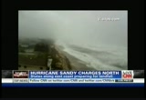
this is a more important storm than irene was and irene was a $15 billion event. >> wow. that was significant. that was connecticut hit very hard. >> connecticut, vermont, new hampshire and into new jersey. >> power was out more than a week in some locations. we'll see you again momentarily. let's check in on a state that is feeling the fury of hurricane sandy right now, and that's north carolina, the outer banks getting the worst of it. maybe the worst of it is actually hitting our george howell. george, you're in kill devil hills. what's new? >> reporter: you know, let's talk about what's happening here on the outer banks. let's talk about the state of north carolina. when you look at the radar, this is the state. you have 40-plus counties that have all declared states of emergency. when you look at the bands here, the bands on the northwest side of the storm, they are affecting this area, and what you're getting is the strong wind. here we're getting the sideways rain mixed with sand here along the ocean, and i also want to talk about storm surge. chad was talking abou
this is a more important storm than irene was and irene was a $15 billion event. >> wow. that was significant. that was connecticut hit very hard. >> connecticut, vermont, new hampshire and into new jersey. >> power was out more than a week in some locations. we'll see you again momentarily. let's check in on a state that is feeling the fury of hurricane sandy right now, and that's north carolina, the outer banks getting the worst of it. maybe the worst of it is actually...
144
144
Oct 27, 2012
10/12
by
CNN
tv
eye 144
favorite 0
quote 0
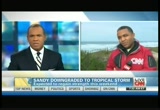
. >> you know, irene was more of a direct hit in a way because this area saw a lot of flooding, saw a lot of rain from it. in fact, i was speaking with someone here just a few minutes ago about what happened in this area, this highway 12. coastal highway 12. there was a major section of that that washed away from the storm. this morning what we're expecting to see, again, that first band of strong winds, the rain that will be coming through, again, the storm has been downgraded, but officials are saying, you know, do not take the storm for granted. it still will be a strong storm that bring winds and anywhere from 40 to 50 miles per hour i was told. but, you know, at this point, people are paying very close attention, i should say, to what's happening out here in the skies. >> as they should. george howell in the outer banks of north carolina, thank you. >>> meanwhile, you know, millions of people could lose power from this storm and the edison electric institute is warning people that outages could last for seven to ten days. right now the area's most vulnerable to power outages are
. >> you know, irene was more of a direct hit in a way because this area saw a lot of flooding, saw a lot of rain from it. in fact, i was speaking with someone here just a few minutes ago about what happened in this area, this highway 12. coastal highway 12. there was a major section of that that washed away from the storm. this morning what we're expecting to see, again, that first band of strong winds, the rain that will be coming through, again, the storm has been downgraded, but...
205
205
Oct 30, 2012
10/12
by
WMAR
tv
eye 205
favorite 0
quote 1
the one on the left is hurricane sandy and right is irene. it is uncommon for a tropical system to track so far, north, especially during this time of the year >> it is so late in the year, it has taken a lot of people by surprise. we were talking about this with lynette and up to the arrival. the wind, the rain and the severity on our side of the storm. this is a perfect mix to the east and west. >>> that's right. that's our 2 degree guarantee. snow to the west. west virginia and western maryland, up to 2 to 3 feet of? snow. so, yes. you know what, even in the forecast i would not be surprised if this moved further to the east. maybe carol county, big wet flakes into the evening and tomorrow morning. that is not out of the question for right now, we're dealing with plenty of rain coming down across the area. with that, we do have flood warnings up. that's going to be through today. maybe even through tomorrow. right now, the entire viewing area is under the flood warning and even points to the north and east. we're dealing with the coastal f
the one on the left is hurricane sandy and right is irene. it is uncommon for a tropical system to track so far, north, especially during this time of the year >> it is so late in the year, it has taken a lot of people by surprise. we were talking about this with lynette and up to the arrival. the wind, the rain and the severity on our side of the storm. this is a perfect mix to the east and west. >>> that's right. that's our 2 degree guarantee. snow to the west. west virginia...
183
183
Oct 29, 2012
10/12
by
FOXNEWS
tv
eye 183
favorite 0
quote 0
joe, i was with you during hurricane irene and this seems like it's much worse. >> it does seem worse already. it was high today and higher now. >> why aren't people leaving? >> well, it takes a long time to get the long time residents off the island and last year there wasn't as much damage as expected and-- >> this is bigger, stronger and much more dangerous and already seeing the water hit against the docks and much more damage. >> it does and tides are pretty high and again, it's two times day and the water will run out and people are fairly comfortable staying the ones that have stayed they've been here a long time. >> well, best of luck to you. geraldo, joe is having a storm party in anticipation of sandy arriving and hopefully spirits will stay up. back to you geraldo. >> geraldo: safe me a rum drink, brother. okay? it sounds okay. and listen folks, this is for real. now, the real danger, i have a dock on the hudson river. i have-- i'm telling you that, i fully anticipate my dock to be over, over run by the river, as it was last year. but this last year was, i think, a three fo
joe, i was with you during hurricane irene and this seems like it's much worse. >> it does seem worse already. it was high today and higher now. >> why aren't people leaving? >> well, it takes a long time to get the long time residents off the island and last year there wasn't as much damage as expected and-- >> this is bigger, stronger and much more dangerous and already seeing the water hit against the docks and much more damage. >> it does and tides are pretty...
234
234
Oct 28, 2012
10/12
by
WMAR
tv
eye 234
favorite 0
quote 0
since irene failed to do the damage here in new york city that many predicted, some people, like this family, who live in the evacuation zone, are refusing to heed the warnings for sandy. >> we have diapers, we have water. you know, just hoping to make the best of it. >> reporter: there are long lines as the supermarket tonight. >> it really is a mad house. >> reporter: yeah. >> like, oh, my god. >> reporter: the streets are crackling not with panic but with with an upbeat, pre-apocalyptic vibe. >> i'm a new yorker. come on, what do you want to do? >> reporter: got to admire her spirit. one piece of breaking news from here in new york. we just learned that the stock market will be closed tomorrow. there were concerns if they tried to stay open, they might lose power during the course of the day. back to you. >> and a few people over your shoulder still getting into the subway. dan harris, thank you. >>> and in addition to the subway shutdown in new york city, air travel is shutting down tonight, as well. so far, more than 6,000 flights have been canceled. ripple effects around the cou
since irene failed to do the damage here in new york city that many predicted, some people, like this family, who live in the evacuation zone, are refusing to heed the warnings for sandy. >> we have diapers, we have water. you know, just hoping to make the best of it. >> reporter: there are long lines as the supermarket tonight. >> it really is a mad house. >> reporter: yeah. >> like, oh, my god. >> reporter: the streets are crackling not with panic but with...
43
43
Oct 28, 2012
10/12
by
MSNBCW
tv
eye 43
favorite 0
quote 0
much different than irene. we have seen people in the last few hours really taking this storm a little more seriously. also new yorkers taking it in stride. >> we have two children. 2 and under. so, it's a bit of a hassle. after going through what we did last year, we are glad the city is taking precaution. >> we are going up state a little bit. stay there a couple days. when they let us back down, we'll cobb back here. if i was young and sting l, we'd still be here. >> reporter: it's not just the mandatory evacuations taking place in the city. you have the subway system that will shut down. first of all, subways at 7:00 tonight. buses at 9:00. you have ferry service in the area that is shutting down as well. the port authority is taking steps to ramp down that construction at the world trade center sight, securing everything they can. broadway shows tonight going dark through tomorrow and perhaps tuesday. >> michelle franzen reporting from lower manhattan. thanks so much. hurricane sandy as we have been talkin
much different than irene. we have seen people in the last few hours really taking this storm a little more seriously. also new yorkers taking it in stride. >> we have two children. 2 and under. so, it's a bit of a hassle. after going through what we did last year, we are glad the city is taking precaution. >> we are going up state a little bit. stay there a couple days. when they let us back down, we'll cobb back here. if i was young and sting l, we'd still be here. >>...
189
189
Oct 29, 2012
10/12
by
WMPT
tv
eye 189
favorite 0
quote 0
this storm instead, first of all, it's much larger than irene. it's coming directly at the coast instead of parallelling it. the effects are spanning hundreds and hundreds of miles, much more so than irene. >> ifill: this storm is hovering with lots of rain centered over one area. how many days do you expect we'll be coping with the fallout from all of that? >> well, i think that it's going to take until wednesday before conditions really significantly improve so that people can get back and start looking at what happened. tomorrow it's still going to be a bad day because the system is going to slow down once it gets towards pennsylvania. it will weaken, but it's going to take a long time for this system to wind down. >> ifill: james franklin of the national hurricane center, thank you. >> you're welcome. >> woodruff: now, a closer look at what officials on the ground have been doing to prepare for the storm's blow. ray suarez spoke by phone a short time ago with cory booker, the mayor of newark, new jersey. suarez: welcome to the program. whethe
this storm instead, first of all, it's much larger than irene. it's coming directly at the coast instead of parallelling it. the effects are spanning hundreds and hundreds of miles, much more so than irene. >> ifill: this storm is hovering with lots of rain centered over one area. how many days do you expect we'll be coping with the fallout from all of that? >> well, i think that it's going to take until wednesday before conditions really significantly improve so that people can get...
237
237
Oct 27, 2012
10/12
by
WRC
tv
eye 237
favorite 0
quote 0
in irene at battery park which is where i am tonight, we had three to six feet. we expect four to eight here and down the jersey shore. that will be higher than what they dealt with during irene. plan on similar scenarios there. look at the rainfall. huge areas of two inches plus, four inches plus. locally ten inches in spots in parts of new jersey and the chesapeake bay. if you remember the state of new jersey was one of those heavily flooded last year with irene. to add insult to injury, west virginia, maryland, pennsylvania and parts of west virginia could get 50 inches of snow with this. add all these ingredients together, that means power outages, some which will last for weeks. pennsylvania, new york, west virginia, an 800-mile-wide damage path with this. on the 108th anniversary of the opening of the subway system in new york we hope in 48 hours, parts of it won't be under water. >> places are holding their breath tonight. jim, thanks. as we come on the air they are beginning to feel the effects on north carolina's outer banks. weather channel meteorologis
in irene at battery park which is where i am tonight, we had three to six feet. we expect four to eight here and down the jersey shore. that will be higher than what they dealt with during irene. plan on similar scenarios there. look at the rainfall. huge areas of two inches plus, four inches plus. locally ten inches in spots in parts of new jersey and the chesapeake bay. if you remember the state of new jersey was one of those heavily flooded last year with irene. to add insult to injury, west...
257
257
Oct 29, 2012
10/12
by
CNNW
tv
eye 257
favorite 0
quote 0
advisory on hurrican irene. we want to go to rob marciano who will tell us what this latest advisory is about. >> it's frightening, up to 85-mile-an-hour wind now. there's a possibility from reading some nuggets from the national hurricane center that it could strengthen some more. we knew we had that possibility. still over the gulf stream where waters are still warm enough to sustain a hurricane. also getting into an environment where it favored strengthening. that's what we've seen. here it is in the satellite picture. 85-mile-an-hour winds. that's a moderate strength category one storm with possible strengthening as we go through time. about 380 miles south of new york city it's movement has picked up northerly about 15 miles an hour and we still expect that turn toward the west later on. this is huge. reading some technical stuff, the tropical storm force winds, diameter nearly 800 miles wide. that is huge. the second largest tropical system we've seen in the last few decades. hurricane force winds extend 1
advisory on hurrican irene. we want to go to rob marciano who will tell us what this latest advisory is about. >> it's frightening, up to 85-mile-an-hour wind now. there's a possibility from reading some nuggets from the national hurricane center that it could strengthen some more. we knew we had that possibility. still over the gulf stream where waters are still warm enough to sustain a hurricane. also getting into an environment where it favored strengthening. that's what we've seen....
321
321
Oct 29, 2012
10/12
by
WRC
tv
eye 321
favorite 0
quote 0
for example, irene was about here. all right? and what we could see is another two and a half, three feet here, major implications, if the water gets into the lower streets of manhattan, and also the subway system. and con-ed has the power to shut it down, and the mayor has to coordinate with the mta, the cross bay, the veteran's memorial bridge, the george washington bridge, just to name a few. they're huge bridges with massive traffic. and of course that was the only way to get around. it was either by car or cab. they were going to keep the bayonne, the 70 miles an hour wind gusts were anticipated to come up this evening through the midnight hour. now, they could choose to open it tomorrow if the winds die down, which certainly they may do. the power losses, approximately a million-plus in 11 states, and that number, brian, i'm afraid is only going to go up. >> all right, jim cantore, southern tip of manhattan, jim, we may check back with you there. and about this power information in the city, as of 5:00 today, con-ed, the po
for example, irene was about here. all right? and what we could see is another two and a half, three feet here, major implications, if the water gets into the lower streets of manhattan, and also the subway system. and con-ed has the power to shut it down, and the mayor has to coordinate with the mta, the cross bay, the veteran's memorial bridge, the george washington bridge, just to name a few. they're huge bridges with massive traffic. and of course that was the only way to get around. it was...
45
45
Oct 28, 2012
10/12
by
MSNBCW
tv
eye 45
favorite 0
quote 0
a lot of people feel that i got through irene, i can get through this. this is a different type of storm. first of all, it's going to cause greater flooding in areas that were not flooded during irene. the wind in areas that were not hit by irene with wind problems, those areas -- people really need to take seriously and be prepared. it's almost getting to the point where it's too late because finding food, finding water, finding flashlights and generators is becoming impossible now. >> sir, good advice. hopefully people are getting good advice. jerome hauer, we'll let you get back to work. we appreciate you taking time out of our schedule. this is msnbc's extended coverage of this october surprise, hurricane sandy looming over a huge area of the eastern u.s., threatening to disrupt things for tens of millions of people, over nearly a quarter of the lower 48 states. we're back after this. when a twinge of back pain surprises him. morning starts in high spirits, but there's a growing pain in his lower back. as lines grow longer, his pain continues to ling
a lot of people feel that i got through irene, i can get through this. this is a different type of storm. first of all, it's going to cause greater flooding in areas that were not flooded during irene. the wind in areas that were not hit by irene with wind problems, those areas -- people really need to take seriously and be prepared. it's almost getting to the point where it's too late because finding food, finding water, finding flashlights and generators is becoming impossible now. >>...
348
348
Oct 29, 2012
10/12
by
KGO
tv
eye 348
favorite 0
quote 0
since irene failed to do the damage here in new york city that many experts predicted, some people, like this family, who live in the evacuation zone, are refusing to heed the warnings for sandy. >> we have diapers, we have water. you know, just hoping to make the best of it. >> reporter: there are long lines at the supermarket tonight. >> it really is a mad house. >> reporter: yeah. >> like, oh, my god. >> reporter: but the streets are crackling not with panic, but with a sort of upbeat, pre-apocalyptic vibe. >> i'm a new yorker. come on, what do you want to do? what do you want to do? panic? we're new yorkers. >> reporter: hard not to enjoy her spirit. agree with her or not. one last bit of news from new york, david. the new york stock exchange announcing late today that they will be closed tomorrow, however, people will still be able to trade stocks online electronically. back to you. >> she was a classic new yorker, dan. love the resiliency. dan harris, thank you. >>> in addition to the subway shutdown in new york city, air travel is shutting down, as well. just this hour, we learned
since irene failed to do the damage here in new york city that many experts predicted, some people, like this family, who live in the evacuation zone, are refusing to heed the warnings for sandy. >> we have diapers, we have water. you know, just hoping to make the best of it. >> reporter: there are long lines at the supermarket tonight. >> it really is a mad house. >> reporter: yeah. >> like, oh, my god. >> reporter: but the streets are crackling not with...
106
106
Oct 29, 2012
10/12
by
CNNW
tv
eye 106
favorite 0
quote 0
looks like it will be higher than irene. that has folks worried in new york harbor and here in new jersey. here's what governor chris christie had to say about his warning to the state yesterday. >>. >> so, don't be stupid, get out and go to higher ground. the margin for me being wrong and you staying at a friend's house is significantly better than winding up with severe energy or death for yourself or for your family. >> some public officials caught heat after hurricane irene. some felt it was overblown. i stand by warnings because it's better to be safe than sorry. this is bigger and in many instances badder than hurricane irene was over 12 months ago. back to you. >> thank you. chris christie is completely right. just go to higher ground just for a couple of days. bring some stuff. if you're wrong, fine. this is not shaping up to be something anything like irene. new york city we're bracing for the impact. mass transit was shut down last night. buses, rail system were brought to a halt. 7 p.m. is when they stopped last n
looks like it will be higher than irene. that has folks worried in new york harbor and here in new jersey. here's what governor chris christie had to say about his warning to the state yesterday. >>. >> so, don't be stupid, get out and go to higher ground. the margin for me being wrong and you staying at a friend's house is significantly better than winding up with severe energy or death for yourself or for your family. >> some public officials caught heat after hurricane...
298
298
Oct 29, 2012
10/12
by
CNNW
tv
eye 298
favorite 0
quote 0
but that was at the height of irene. irene came on shore well to our north. this storm will bring this water up as much as another eight feet, which means the boardwalk will be compromised and the water will be going over the top of that. that's why this area's been evacuated. shelters are open. there's been 600 people that have taken advantage of that. just spoke with an official from the fire department here. a few minor calls into the asbury park fire department with some trees and some power lines down but no widespread damage as of yet. and no rescue operations under way. they certainly hope that trend will continue through the overnight period. in the next 12 hours, that's when things are going to get really hairy. carol? >> rob marciano reporting live from asbury park. thank you, rob, appreciate it. if you want a sense of just how seriously local officials are taking this approaching storm, consider this -- the new jersey weather service issued this dire warning yesterday for anyone ignoring the evacuation orders. quote, if you are reluctant, think abo
but that was at the height of irene. irene came on shore well to our north. this storm will bring this water up as much as another eight feet, which means the boardwalk will be compromised and the water will be going over the top of that. that's why this area's been evacuated. shelters are open. there's been 600 people that have taken advantage of that. just spoke with an official from the fire department here. a few minor calls into the asbury park fire department with some trees and some...
1,235
1.2K
Oct 29, 2012
10/12
by
CNNW
tv
eye 1,235
favorite 0
quote 0
we got through irene. this will be tougher, but we can get through this also. >> are you finding people are heeding the warnings already, sir? >> yes. we have about 150-plus folks in our shelters. we're getting tweet information @michaelnutter. our 311 system is getting a lot of calls. people asking for information. i think people know we're taking this seriously. president obama signed an emergency declaration. we're working through our state and governor corbett. we're constantly pumping out information to folks. people know that this is the real deal. they knew that irene was tough. this is going to be tougher and probably last longer because this is a slow moving storm. so it's just going to expand on the amount of rain and wind and that's a tough combination for us in a big old northeastern city. >> it sure is. mayor michael nutter joins us from philadelphia. thank you, sir, for your time. we certainly appreciate it. let's head to baltimore, shall we? let's chat with stephanie rowelings blake. she's t
we got through irene. this will be tougher, but we can get through this also. >> are you finding people are heeding the warnings already, sir? >> yes. we have about 150-plus folks in our shelters. we're getting tweet information @michaelnutter. our 311 system is getting a lot of calls. people asking for information. i think people know we're taking this seriously. president obama signed an emergency declaration. we're working through our state and governor corbett. we're constantly...
150
150
Oct 27, 2012
10/12
by
CNNW
tv
eye 150
favorite 0
quote 0
it didn't generate a lot like irene didn't generate. so if this thing stays kind of like the irene, this becomes not a big deal. but that's not the forecast. not a single model does that. every model turns it back into the northeast, either from new york city all the way down to north carolina and then here's the rub that we've never gone through this before. there's not been ever an instance where a computer model has had to work this out in its head or in its computer. there's a cold air mass back here, there's a low here, and another low here, and they're going to combine. what is going to happen when those two combine, we honestly simply don't know. there's not been any history for this in the computer program. the program's only been running for 25 years. maybe a little bit less. >> so just explain to me briefly, what is so unique about that, that combination? >> you have the moisture from a tropical storm and then you have the wind and the energy and even the potential for snow with a low pressure that is a normal low pressure. it
it didn't generate a lot like irene didn't generate. so if this thing stays kind of like the irene, this becomes not a big deal. but that's not the forecast. not a single model does that. every model turns it back into the northeast, either from new york city all the way down to north carolina and then here's the rub that we've never gone through this before. there's not been ever an instance where a computer model has had to work this out in its head or in its computer. there's a cold air mass...
232
232
Oct 28, 2012
10/12
by
MSNBCW
tv
eye 232
favorite 0
quote 0
we lucked out with irene, and i don't know. this may be worse. >> nbc's tom strong traung is l rehoboth beach, delaware. any residents left? >> they have about eight hours, the governor issues a mandatory evacuation area. everybody must be out by 8:00. look down the beach, have you several dozen people trying to get their last glimpse. right now, low tide. looks pretty impressive. come high tide, around 6:30, it wouldn't be a surprise if we didn't see water coming up to this fence here. all around rehoboth beach, a lot of businesses boarded up. people making runs to the grocery store, water short, bread is short. people did what they could in terms of preparation. they had about eight hours, around that time, this area will be shut down. cut off the bridges and roads into here it won't be a very pleasant place to stay if the electricity is going to go out. which is a likelihood. 2,000 utility workers and we're talking about the maryland/dc area, baltimore areas, and states of emergencies in those areas as well. a lot of people
we lucked out with irene, and i don't know. this may be worse. >> nbc's tom strong traung is l rehoboth beach, delaware. any residents left? >> they have about eight hours, the governor issues a mandatory evacuation area. everybody must be out by 8:00. look down the beach, have you several dozen people trying to get their last glimpse. right now, low tide. looks pretty impressive. come high tide, around 6:30, it wouldn't be a surprise if we didn't see water coming up to this fence...
777
777
Oct 27, 2012
10/12
by
WMAR
tv
eye 777
favorite 0
quote 0
damage from irene topped $14 billion. and sandy could wreak even more havoc. >> certainly having lived through it. i lost everything in my basement. i had up to ten feet of water in my house. this is a concern. >> reporter: governor cuomo has declared a state of emergency in preparation for sandy's impact. and mayor michael bloomberg warned new york city residents to brace themselves. >> there's the possibility of parts of our city flooding or high winds that could force certain bridges to be closed. >> reporter: last year, in advance of irene, mayor bloomberg made the unprecedented order to evacuate low-lying areas of the city and shut down the subway system. as sandy barrels north, the city's more than 7 million strap hangers await a decision about another possible shutdown. and mayor bloomberg says the subway system will shut down if the wind speeds exceed 39 miles per hour. now, he also recommends that residents put together a go pack with all of the essentials, should you need to evacuate at a moment's notice. >> pot
damage from irene topped $14 billion. and sandy could wreak even more havoc. >> certainly having lived through it. i lost everything in my basement. i had up to ten feet of water in my house. this is a concern. >> reporter: governor cuomo has declared a state of emergency in preparation for sandy's impact. and mayor michael bloomberg warned new york city residents to brace themselves. >> there's the possibility of parts of our city flooding or high winds that could force...
140
140
Oct 26, 2012
10/12
by
FOXNEWS
tv
eye 140
favorite 0
quote 0
>>guest: well, we should look at irene. this will cause at least as much problem as irene. i expect this to get their act right back together and do not be viced if this is a category two or category three by sunday before it turned to the northwest. it is very warm water in the atlantic. very warm. we back in the 1950s. we had ten major hurricanes on the east coast including hazel in 1954 in mid-october which had a path similar to this but it was to the west. that want into north carolina and you notice this storm is attacking from the southeast, right? and basically, it is that path superimposed to the east so hazel led to wind gusts at 100. >>neil: what makes it a mess for the northeast, combining with the other areas? >>guest: what makes it, (a), it moves slow and intensifies miling water to the northeast beaches. that is first. >>neil: and it sits? >>guest: full moon and look at the way the coast is shaped. it is shaped so you funnel water into new york city and push the storm surge in. the normal hurricane like irene comes along the coast and heads for long island and
>>guest: well, we should look at irene. this will cause at least as much problem as irene. i expect this to get their act right back together and do not be viced if this is a category two or category three by sunday before it turned to the northwest. it is very warm water in the atlantic. very warm. we back in the 1950s. we had ten major hurricanes on the east coast including hazel in 1954 in mid-october which had a path similar to this but it was to the west. that want into north...
228
228
Oct 28, 2012
10/12
by
KGO
tv
eye 228
favorite 0
quote 0
last year irene left 7 million homes without power. so even before sandy's hurricane winds and rain, utility crews are out trimming tree, putting crews in place. >> it looks pretty ominous. >> reporter: vince mahone has been with the utility that serves south jersey including atlantic city for 28 years and has never seen a storm like this and knows a lot of his customers are going to lose electricity. >> the best thing is to be prepared and i think that's what we are. we're prepared for what the worst can bring. >> reporter: new jersey's governor declaring a state of emergency, warned residents they could be without power for a week to ten days, and chris christie says he's worried that residents might put generators indoors or run extension cords in a haphazard way to get some electricity. >> that's a good new jersey rule, if it looks stupid, it is stupid. >> reporter: already crews from mexico to iowa are in their trucks driving to the east coast in front of sandy's wrath. so how bad could it be? believe it or not, this guy thinks he
last year irene left 7 million homes without power. so even before sandy's hurricane winds and rain, utility crews are out trimming tree, putting crews in place. >> it looks pretty ominous. >> reporter: vince mahone has been with the utility that serves south jersey including atlantic city for 28 years and has never seen a storm like this and knows a lot of his customers are going to lose electricity. >> the best thing is to be prepared and i think that's what we are. we're...
212
212
Oct 29, 2012
10/12
by
CNNW
tv
eye 212
favorite 0
quote 0
irene, this was as high as irene got, and i think we'll get another couple of feet on top. >> another couple of feet on top of what we're experiencing now, again. water -- when you go down the street it's high thy-high already. >> all right. i'm curious how is he going to get those kids out, but we've run out of time, so maybe we'll get back to you, and maybe he can help us understand how he is moving the family out with that little boat. >> if are you trying to fly out of the northeast, are you probably out of luck. thousands of flights canceled because of the storm. we'll show you where. i've been a superintendent for 30 some years at many different park service units across the united states. the only time i've ever had a break is when i was on maternity leave. i have retired from doing this one thing that i loved. now, i'm going to be able to have the time to explore something different. it's like another chapter. anncr: every president inherits few have faced so many. four years later... our enemies have been brought to justice. our heroes are coming home. assembly lines are humm
irene, this was as high as irene got, and i think we'll get another couple of feet on top. >> another couple of feet on top of what we're experiencing now, again. water -- when you go down the street it's high thy-high already. >> all right. i'm curious how is he going to get those kids out, but we've run out of time, so maybe we'll get back to you, and maybe he can help us understand how he is moving the family out with that little boat. >> if are you trying to fly out of the...
269
269
Oct 28, 2012
10/12
by
WJLA
tv
eye 269
favorite 0
quote 0
. >> reporter: sandy could create a storm surge larger than last year's hurricane irene. possibly filling the subway tunnels with water. >> lower manhattan is the most vulnerable spot for a storm surge. >> no doubt about they expect this to be a large problem for central new jersey, including philadelphia, atlantic city, new york city all of the way up toward boston. something that we need to pay attenti attention to. >>> now, potentially new york city, where hurricane irene last year wasn't so bad in the city itself, what would you say to people who are tempted to write this off? >> i want to remind folks about that hurricane, it was a bad storm, dan, it just didn't deliver the wind damage that new york city expected and the surge wasn't really here. but if you look innd where it was catastrophic flooding and so many folks were acted that storm. it was a terrible storm. this storm hurricane center said that it will have all of those elements focused on these big population areas, and new york city is one of them. i'm going to ask everyone to be prepared. >> all right, be
. >> reporter: sandy could create a storm surge larger than last year's hurricane irene. possibly filling the subway tunnels with water. >> lower manhattan is the most vulnerable spot for a storm surge. >> no doubt about they expect this to be a large problem for central new jersey, including philadelphia, atlantic city, new york city all of the way up toward boston. something that we need to pay attenti attention to. >>> now, potentially new york city, where...
 Live Music Archive
 Librivox Free Audio
 Metropolitan Museum
 Cleveland Museum of Art
 Internet Arcade
 Console Living Room
 Books to Borrow
 Open Library
 TV News
 Understanding 9/11